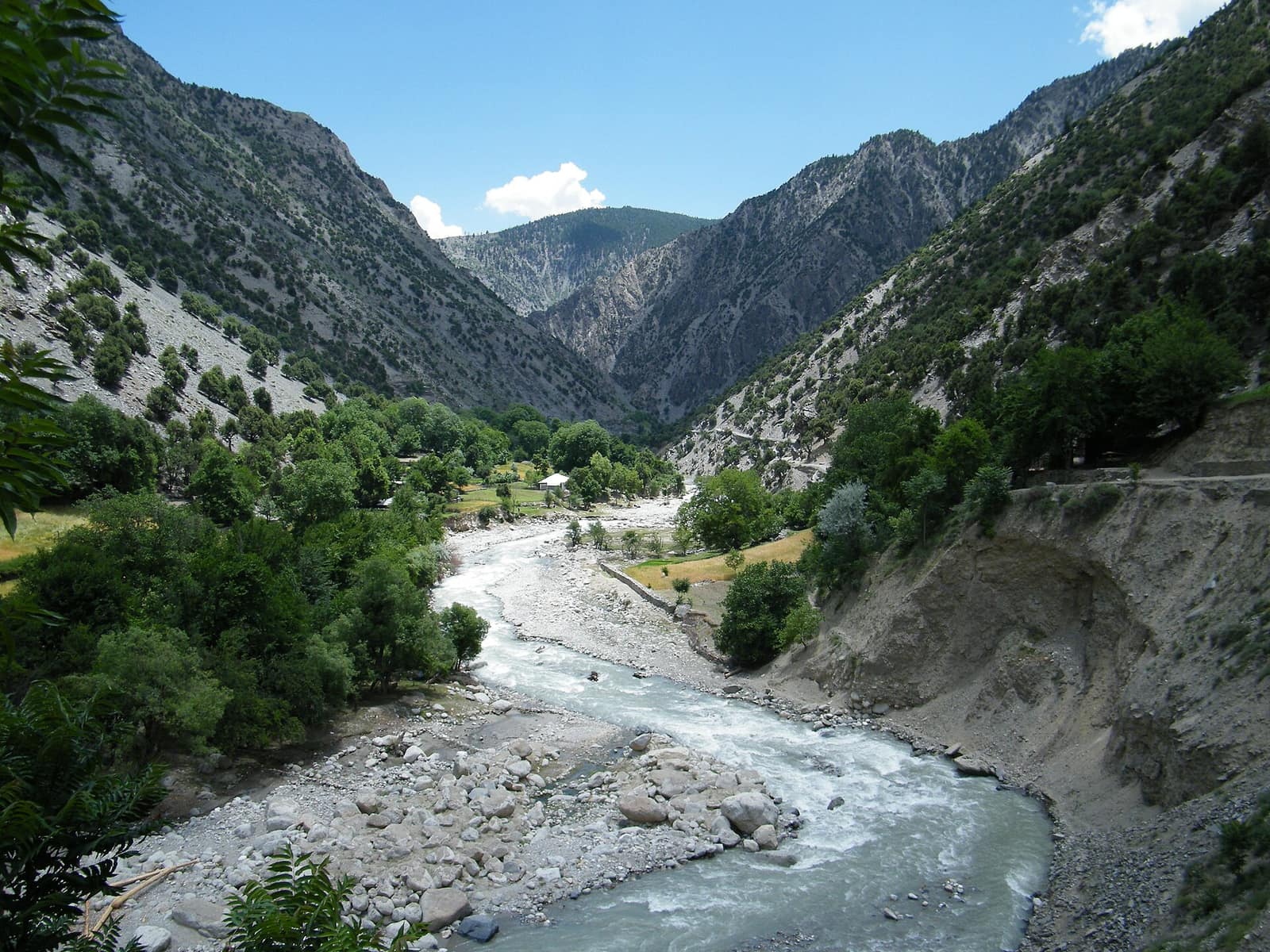
Chitral and the Kalash valleys
The district on the far side of Nuristan's eastern crest, the three valleys where the Kalash live, and the Nuristanis who settled beside them in 1896.
The other side of the mountain
Stand on the crest above Bargi Matal, or at the head of the Bashgal, and the country falling away to the east is Chitral. It is in Pakistan, and it has been on the far side of a border since 1893, but for most of history the border was not there, and the people on both sides were more alike than different. The Kalash of Chitral's three western valleys still keep a religion closely related to the one Nuristan lost in 1896, and Nuristani families live in Chitral because their great-grandparents fled there when the Amir's army came: Kati speakers from the Bashgal, and, as Waygal remembers it, a great many from Waygal too.
This page is about Chitral as Nuristan's neighbour: where it is and how it sits against our valleys, where the Kalash valleys are, the Nuristanis who live in Chitral today, and how to visit. The Kalash have pages of their own on this site, linked below. We have written it from the Nuristani side, which is the side rarely told, and checked it against the scholarship. Where the two sides remember things differently, we say so.
- Where
- Khyber Pakhtunkhwa, Pakistan, over the passes east of Nuristan
- The border
- The Hindu Kush crest, fixed as the Durand Line in 1893
- Highest peak
- Tirich Mir, 7,708 m, the highest in the Hindu Kush
- The river
- The Chitral river, which becomes the Kunar
- The Kalash
- About 7,500 Kalasha speakers in the 2023 census
- Kalash valleys
- Bumburet, Rumbur and Birir
- Nuristanis there
- Kati speakers in a handful of villages, 12,000 or more
- Way in
- The Lowari tunnel from Dir, or a flight from Peshawar
Chitral, east of the crest
Chitral is the country beyond the right-hand edge of the Nuristan map: the Kalash valleys run up towards Bargi Matal and Kamdesh, and Chitral's river becomes the Kunar.
Chitral is the northernmost district of Khyber Pakhtunkhwa, a long valley running north to south between the Hindu Kush and the Hindu Raj, 14,850 square kilometres with about 414,000 people, split since 2018 into Upper and Lower Chitral. Its western wall is the main crest of the Hindu Kush, and along that crest runs the border with Afghanistan: with Badakhshan and the Wakhan in the north, with Nuristan in the middle, with Kunar in the south. Tirich Mir, at 7,708 metres the highest mountain in the whole Hindu Kush, stands above the district capital.
The river that runs through Chitral town is the same river that runs past Asadabad. It rises in the far north of the district, flows south as the Chitral river, crosses into Afghanistan below Arandu and there becomes the Kunar, which takes in the Landai Sin from the Bashgal and the Pech from Parun and Wama before it reaches the Kabul river at Jalalabad. Nuristan's eastern rivers and Chitral's one river are a single system, and the map on this page shows where they meet.
The Kalash valleys are three side valleys on Chitral's western edge, Bumburet, Rumbur and Birir, running west from the Chitral river up into the mountains towards Nuristan. Their heads are a hard day's walk from the upper Bashgal. Until the border hardened, the passes above them were the way Kafirs, and then Nuristanis, went to and fro: to trade, to raid, to marry and, in the winter of 1895 to 1896, to escape. George Scott Robertson walked in that way in 1890, up Bumburet and over into the Bashgal, to spend his year in Kamdesh.
The people who never converted
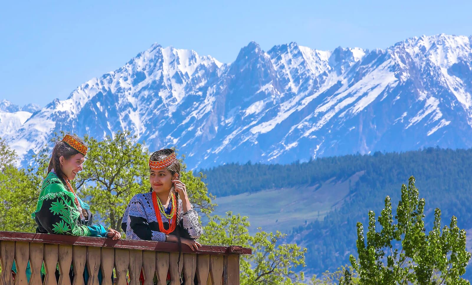
Three valleys on Chitral's western edge
The Kalash are the people of those three valleys: about 7,500 speakers of Kalasha in the 2023 census, of whom about 4,000 still follow the old religion. They are the last people in the Hindu Kush who never converted. They lived under the Mehtar of Chitral, on the British side of the line drawn in 1893, and the Amir's army of 1895 never reached them.
Their religion is a cousin of the one Nuristan followed until 1896, with a creator, a company of gods, goat sacrifice at open altars and four festivals through the year, and their houses, dress and food are close to ours. We have given the Kalash two pages of their own: one on the people, their origins and their language, and one on the religion and its festivals.
Chitral itself is not Kalash. Its people are mostly the Khowar-speaking Kho, Muslims for centuries, with a princely history of their own and a capital that was a state until 1947. The Kalash are three valleys on Chitral's edge, the way Nuristan is ten valleys on Afghanistan's edge.
The families who went over the passes
When the Amir's army entered the Bashgal in the winter of 1895 to 1896, families who would not convert, or would not stay, went over the passes into Chitral, where the Mehtar let them settle. One chief of Bargi Matal, Sardar Kashmir, is recorded as crossing with about six hundred followers. Their descendants live in a handful of villages on Chitral's western edge, in and around the Kalash valleys. They speak Kati, the language of Kamdesh and Bargi Matal, in the dialect Chitral calls Sheikhani, from the name the converted Kafirs were given, and a survey in 2019 counted more than 12,000 of them. They became Muslims in Chitral, as their cousins did in Nuristan, and they have kept the same names, the same carving on the door, and the memory of the Bashgal villages they left.
In Waygal the story is told with a different emphasis. What people there say, and what we grew up hearing, is that when the Amir's army came a great many from Waygal, not only from the Bashgal, went over the mountains to Chitral rather than convert or be ruled, and that this is why the Kalash look, dress and keep house so much like the people of Waygal. To a Waygal ear the Kalash language sounds close to Waygali. The linguists file the two in different branches, Kalasha with the Indo-Aryan languages and our Waygali-ala, which the books call Kalasha-ala, with the Nuristani, and both things can be true: the two share a name in the books, a large stock of words and centuries of marriage and trade across the passes, and a shared vocabulary is what a listener hears first. What Waygal remembers and what the scholars record agree on the main point, that the people on the two sides of the crest are family, and only the Kalash kept the old religion.
The traffic did not stop in 1896. Nuristani men went to Chitral for work and trade through the twentieth century, the pakol came into Nuristan from Chitral in exactly those years, and families on both sides know their relations across the crest. Today the border posts along the Chitral river are not open to ordinary travellers, so a Nuristani visiting relatives in Chitral goes round by Jalalabad, Torkham and Peshawar, a journey of days for a distance you can see from a ridge above Bargi Matal.
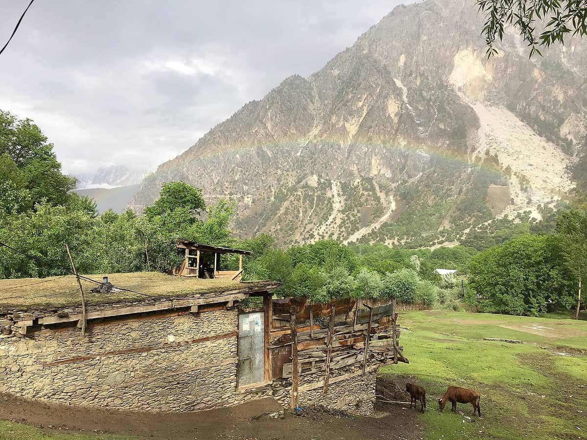
A house in Bumburet: stone below, timber above, a flat roof and the cattle by the door. Anyone from Nuristan will know it.
How to get to Chitral and the Kalash valleys
Chitral is reached from Peshawar by road through the Lowari tunnel, opened to traffic in 2017 under the pass that used to close the district for months each winter, a drive of ten to twelve hours, or by a short flight from Peshawar when the weather allows. Chitral town has hotels; the Kalash valleys have guesthouses, and Bumburet is the most visited of the three. Foreign visitors have needed permits or registration for the Kalash valleys at different times, so check the current rules with a Pakistani operator before you travel. May brings Chilam Joshi and December Chawmos; both are religious occasions rather than performances, and visitors who remember that are welcome.
From the Nuristan side you cannot cross. What you can do is stand where the old road began. The upper Bashgal above Bargi Matal, where the paths to Chitral leave the valley, is the closest a visitor to Nuristan can get to the Kalash, and our guides know the way.
Asked about Chitral
Is Chitral in Afghanistan or Pakistan?
Pakistan. Chitral is the northernmost district of Khyber Pakhtunkhwa, and it borders Afghanistan's Badakhshan, Nuristan and Kunar provinces along the crest of the Hindu Kush. It was a princely state until 1947 and has been part of Pakistan since.
Where are the Kalash valleys?
In Lower Chitral district, on the western side of the Chitral river. There are three, Bumburet, Rumbur and Birir, and they open about twenty kilometres south of Chitral town; the road leaves the main valley at Ayun. Their heads reach up to the Afghan border, with Nuristan's Bashgal valley on the far side.
Can you travel from Nuristan to Chitral?
Not directly. The passes that once joined the Bashgal to the Kalash valleys are closed to travellers, and the border posts along the Chitral river are not open to them either. The way round is by Jalalabad, Torkham and Peshawar, then up to Chitral by road through the Lowari tunnel or by air.
Who are the Nuristanis of Chitral?
Descendants of families from Nuristan's Bashgal valley who crossed the passes in the winter of 1895 to 1896 rather than submit to the Amir's army. They settled in a handful of villages at the heads of the Kalash valleys and nearby, became Muslims within a generation or two, and are known in Chitral as Sheikhan or Bashgalis. A survey in 2019 counted more than 12,000 of them.
Which language do the Nuristanis of Chitral speak?
Kati, called Kamkata-viri by linguists and Sheikhani in Chitral, the same language as Kamdesh and Bargi Matal in Nuristan's Bashgal valley. Most also speak Khowar, the main language of Chitral, and Urdu.
How do you get to Chitral and the Kalash valleys?
From Peshawar, by road through the Lowari tunnel, a drive of ten to twelve hours, or by a short flight when the weather allows. From Chitral town the Kalash valleys are reached by way of Ayun. Foreign visitors have needed permits or registration at different times, so check the current rules before travelling.
On this site
- The Kalash people: who they are and where they come from
- Kalasha religion: the gods, the festivals and the rules
- Nuristani religion: Islam today, the old gods before 1896
- Kafiristan: the history of Nuristan before 1896
- The Nuristani languages, valley by valley
- Who are the Nuristani people?
- Bargi Matal, the district on the Chitral crest
- Kunar, where the Chitral river becomes the Kunar
- All of Nuristan's neighbours, with the map
- The pakol: the hat Nuristan took from Chitral
- Wikipedia: Kalash people (population from the 2023 census, religion, festivals, conversion)
- Wikipedia: Kalasha language (classification and the Kalasha-ala confusion)
- Wikipedia: Chitral District (area, population, the 2018 split, passes, the Lowari tunnel)
- Wikipedia: Katë language (Kati speakers in Chitral and the Sheikhani dialect)
- UNESCO: Suri Jagek, inscribed 2018 on the List of Intangible Cultural Heritage in Need of Urgent Safeguarding
- Michael Witzel, Kalash Religion (the Kalash pantheon and its Vedic and Kafir relatives)
- George Scott Robertson, The Kafirs of the Hindu-Kush (1896), his route in from Chitral and the festivals of Kamdesh
- Wikipedia: Nuristanis (the 2019 survey of Nuristanis in Chitral)
Photographs
- The river in the Rumbur valley: photograph by Majduddin, CC BY-SA 3.0, via Wikimedia Commons
- Kalash women in Birir valley, Chitral: photograph by Tahsin A Shah, CC BY-SA 4.0, via Wikimedia Commons
- A house in Bumburet: photograph by Numan Ali, CC BY-SA 4.0, via Wikimedia Commons
The site's own photographs are of Nuristan; these three are used under their licences until we have our own from Chitral.
Plan your Nuristan journey
Ready to plan a visit, source Nuristani products, or discuss an investment? Your message goes to Obaid, who is from Nuristan, and his team in Afghanistan and the UK. We reply to every message.